
A Refined Strategy for Removing Composite Errors of SAR Interferogram
发布时间:2018-04-25
点击次数:
影响因子:3.966
DOI码:10.1109/LGRS.2013.2250903
发表刊物:IEEE Transition on Geoscience and Remote Sensing Letters
关键字:Composite errors, elevation-dependent phase error, linear model, synthetic aperture radar interferometry (InSAR), quadratic model.
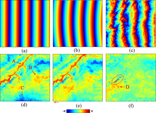
摘要:In standard differential synthetic aperture radar interferometry, there could still be a residual tilt (orbital error) in the interferometric phase due to inaccurate baseline estimation. We demonstrated theoretically that the orbital errors were partially elevation dependent. On the basis of this, we introduced an elevation-dependent item to the conventional polynomial model to simulate, and therefore, compensate the orbital errors, as well as the small scale topographic and/or topography-related phase errors. Robust regression approach was suggested to determine the parameters of the proposed model. The model was validated with both synthetic and real ALOS PALSAR data of the Zhouqu, China mudslide. The synthetic test indicated that upon applying the refined model, the accuracies of phase measurements were improved by nearly two times, compared to those using conventional linear and quadratic models. The real data experiment indicated that after utilizing the refined model, the correlation between the interferogram and the digital elevation model of Zhouqu reduced to about 1/5 of those using linear and quadratic models. This demonstrates that the elevation-dependent phase components have been largely removed by the new model. More importantly, the interferogram corrected by the new model visibly disclosed the deformation area affected by the Zhouqu mudslide.
论文类型:期刊论文
学科门类:工学
一级学科:测绘科学与技术
文献类型:J
卷号:11
期号:1
页面范围:143-147
是否译文:否
发表时间:2014-01-01
收录刊物:SCI
发布期刊链接:https://ieeexplore.ieee.org/document/6509971
附件:
2014-GRSL-A_Refined_Strategy_for_Removing_Composite_Errors_of_SAR_Interferogram.pdf