
2016年2月6日台湾美浓Mw6.4地震震源参数的InSAR和GPS反演
发布时间:2020-04-25
点击次数:
2016年台湾美浓Mw6.4地震震源参数的InSAR和GPS反演
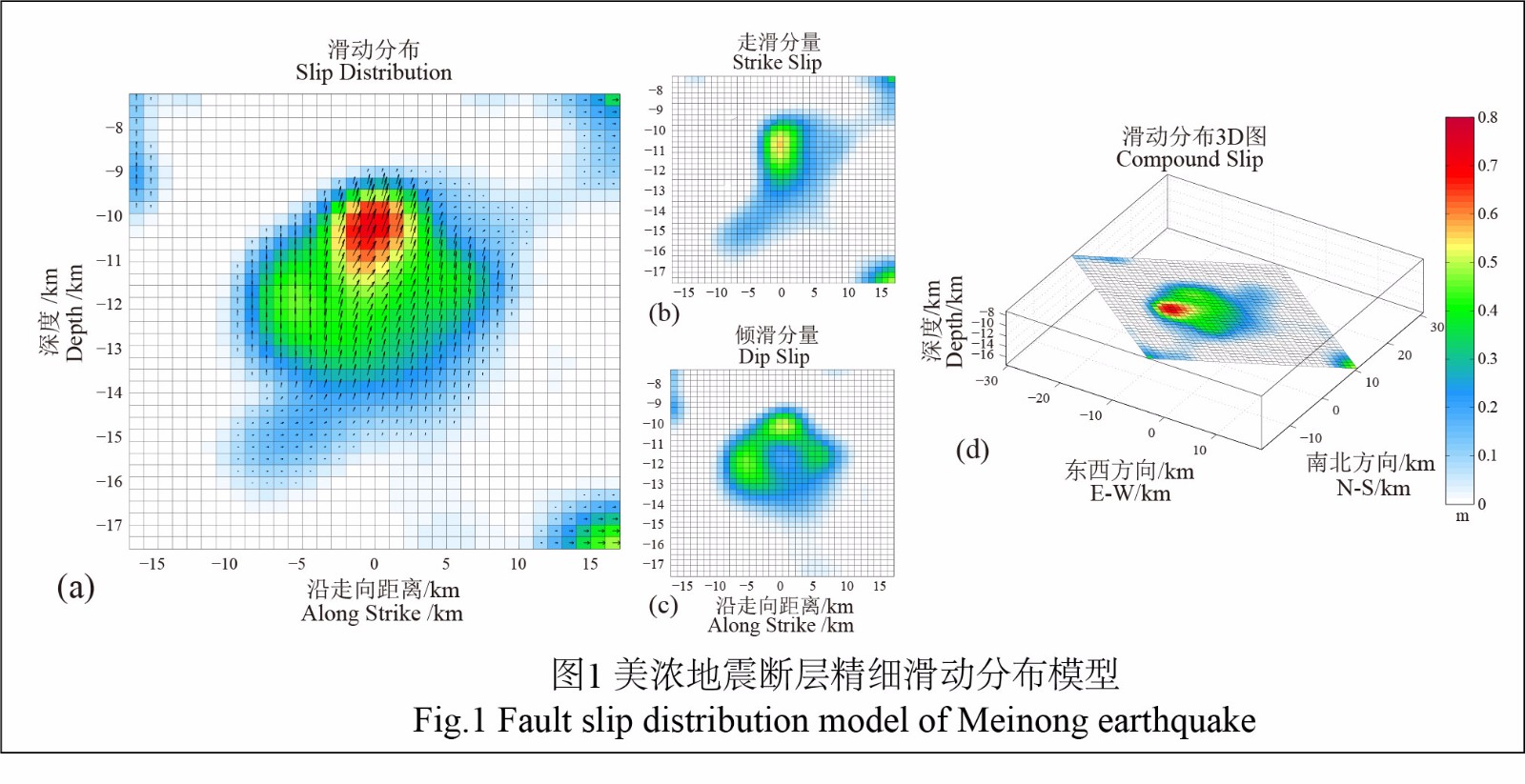
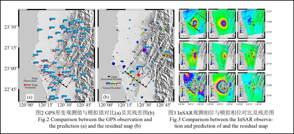
2016年2月6日台湾西南部高雄市美浓区发生了Mw6.4地震. 我们结合ALOS2卫星升降轨、Sentinel-1A升轨SAR数据,采用两轨差分干涉技术获取了该区域的同震形变场,形变结果表明震中西北部以抬升为主,最大视线向形变量约为11.2cm. 基于均匀位错模型和多峰值粒子群(MPSO)算法,利用InSAR和GPS形变数据联合反演了美浓地震的断层几何参数,结果表明震源中心位于22.920°N,120.420°E,深度约12km,发震断层长度约15km,走向角307°,倾角16.5°,平均滑动角为51.5°,此次地震是以逆冲倾滑兼左旋走滑的破裂模式. 利用格网迭代搜索法得到最优倾角为15.7°,GPS和InSAR最优权比为18:1,最优平滑因子为0.06. 基于非均匀位错模型,利用非负最小二乘方法进行线性反演,结果显示最大倾滑和走滑量分别为51.7cm和55.3cm,对应矩震级为Mw6.38,略小于GCMT(Mw6.4)的结果. 通过与已有文献的比较和对该区域断层构造的分析,发现美浓地震的发震断层为单一断层的解释更为合理,我们推测发震断层是位于左镇、后甲里等断层之间的一条东南-西北走向往东北倾斜的盲断层,并初步推测2010年Mw6.3甲仙地震也同该断层有关.
InSAR and GPS Earthquake Source Parameter Inversion for the 2016 Mw6.4 Meinong, Earthquake
On February 6, 2016, an Mw6.4 earthquake struck the Meinong district of Kaohsiung city in Taiwan, China. Various researches have been conducted on the earthquake. Most of these researches are based on seismic data and no consensus has been reached on the fault structure and focal parameters yet. Surface displacement obtained by InSAR technology is widely used in earthquake studies because of its high resolution and accuracy with large and continuous coverage. Therefore, this study selected InSAR and GPS data to investigate the focal mechanism and slip distribution of the 2016 Meinong earthquakes.
Using the dual-track differential interferometric SAR (D-InSAR) technology, we extracted the coseismic deformation filed of this earthquake with synthetic aperture radar (SAR) data (both the ascending and descending) from satellite ALOS2 and the ascending data from satellite Sentinal-1A. The results show that the maximum deformation occurred in the western of the epicenter, with a uplift around11.2cm.
The uniform dislocation model and multiple peak particle swarm optimization (MPSO) algorithm was employed to determine the fault geometry parameters of this earthquake based on the InSAR and GPS data. The results show that the rupture is a reverse fault with sinistral strike-slip with the average slip angle of 51.5°. The deformation center is at 22.920°N, 120.420°E with a depth of 12km.The rupture plane is about 15km with a strike angle of 307° and a dip angle of 16.5°. The optimal dip angle (15.7°), weighting ratio(18:1) between GPS and InSAR and the smoothing factor(0.06) obtained by the grid iteration method together with the non-uniform determine model and the non negative least squares method are used to obtain the detailed slip distribution. The results show that the maximum value of dip slip and strike slip are 51.7 and 55.3cm, respectively. The moment magnitude of the non-uniform determine model is Mw6.38, slightly smaller than the results of GCMT(Mw6.4).
The comparison between our research and previous researches and the analysis of the regional faults indicate that a single fault geometry is more reasonable and it can fit both the GPS and InSAR data well. We also find that the ruptured fault is a blind fault located in the area among Zouchen fault and Chishan fault with an ES-WN strike and dip forward to ES. So we believe this fault should have some relation with the 2010 Mw6.3 Jiashian earthquake.
引用格式:
王乐洋, 高华, 冯光财. 2016 年台湾美浓Mw 6.4地震震源参数的InSAR和GPS 反演[J]. 地球物理学报, 60(7): 2578-2588.
WANG Le-Yang, GAO Hua, FENG Guang-Cai .2017.InSAR and GPS inversion for source parameters of the 2016 MW6.4 Meinong, Taiwan earthquake.Chinese Journal Geophysics,60(7): 2578-2588,doi: 10.6038/cjg20170707