ReseachWe are a research group in geophysics that focuses on the use of satellite radar interferometric (InSAR) and high resolution optical images to measure ground deformation due to a variety of geophysical processes, e.g. earthquakes cycle, mining subsidence and pressure changes in reservoirs. Field locations we have focused on include the place nearby China, such as, the whole China, Southeast Asia, Japan. Besides investigating models of lithospheric dynamics, we also study the method & tools that help us to obtain the accuracy surface displacement measurements, e.g. advance InSAR technique, high resolution DEM generation.
(1) Earthquakes Mechanism Using InSAR We are using InSAR data to develop an incomplete catalog of well-constrained hypocenters and mechanisms for a selected set of small shallow earthquakes. In particular, we are interested in earthquakes that can be reasonably modeled as point sources or simple planar sources with relatively simple source time functions. The only limitation to this effort is that any particular event must generate surface deformation detectable with satellite InSAR. This limitation is a function of the size and depth of the earthquake, the number of interferograms available for stacking, and maintaining interferometric correlation. Reference Feng G.C., Li Z.W., Xu B., Shan X.J., Zhang L. and Zhu J.J. Coseismic Deformation of the 2015 Mw 6.4 Pishan, China, Earthquake, Estimated from Sentinel1 and ALOS2 Data, Seismological Research Letters, 2016 (accepted). Feng, G. C., Li, Z W, Shan, X J. 2015b. Geodetic Model of the April 25, 2015 Mw 7.8 Gorkha Nepal Earthquake and Mw 7.3 Aftershock Estimated from InSAR and GPS Data. Geophysical Journal International, 203(2): 896-900. doi: 10.1093/gji/ggv335. Feng, G. C. et al., Source parameters of the 2014 Mw 6.1 South Napa earthquake estimated from the Sentinel 1A, COSMO-SkyMed and GPS data, Tectonophysics (2015), 655, 139-146, DOI: 10.1016/j.tecto.2015.05.018 Zhou Hui, Feng G.C.(*), Li Zhi-Wei, Xu Bing, Lei Guang-Yuan. The fault slip distribution of the Myanmar Mw6. 8 earthquake inferred from InSAR measurements, Chinese Journal of Geophysics, 2013, 56(9): 3011-3021.
(2) SAR and optical images pixel offset tracking measurement
In complement to seismological records, the knowledge of the ruptured fault geometry and of the co-seismic ground deformation are key data to investigate the mechanics of seismic rupture. This information can be retrieved from sub-pixel correlation of pre- and post-earthquake remotely sensed optical images. However, this technique suffers from a number of limitations, mostly due to uncertainties on the imaging systems and on the platform attitudes, leading to strong distortions and stereoscopic effects. Reference Feng, G.C., E. A. Hetland, X. Ding, Z. Li, and L. Zhang (2010), Coseismic fault slip of the 2008 Mw 7.9 Wenchuan earthquake estimated from InSAR and GPS measurements, Geophys. Res. Lett., 37, L01302, doi:10.1029/2009GL041213. Feng G.C., XU Bing, SHAN Xin-Jian et al .2015.Coseismic deformation and source parameters of the 24 September 2013 Awaran, Pakistan Mw7.7 Earthquake derived from optical Landsat 8 satellite images. Chinese Journal Geophysics, 58(5): 1634-1644, doi: 10.6038/cjg20150515.
(3) Temporal InSAR algorithms Interferometric Synthetic Aperture Radar (InSAR), also referred to as SAR Interferometry, is the measurement of signal phase change between two images acquired over the same area at different time. When a point on the ground moves, the distance between the sensor and the point also changes and so the phase value recorded by a SAR sensor flying along a fixed orbit will be affected, too. Reference XIONG Wenxiu, FENG Guangcai(*), LI Zhiwei, DU Yanan, LI Ning. High Quality Targets Selection in SBAS-InSAR Technique by Considering Temporal and Spatial Characteristic. Acta Geodaetica et Cartographica Sinica, 2015, 44(11): 1246-1254. Zhang, L., Ding, X., Lu, Z., Jung, H.-S. , Hu, J. , Feng, G.(2013), A novel multitemporal InSAR model for joint estimation of deformation rates and orbital errors, IEEE Transcation on Geoscience and Remote Sensing,10.1109/TGRS.2013.2273374. (4) InSAR infrastructure construction monitoring
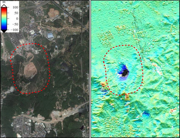
InSAR is an all-stage monitoring tool for engineering projects: from the design to the construction and operation phases as well. We can provide an important input to all stages of any construction project by identifying unstable areas affected by surface movements and reconstructing their displacement history. InSAR also gives a unique support in surveying for underground construction projects. InSAR measurement are used to: (1) determine existing surface movements during site selection processes; (2)assess stability impacts of engineering activity and complement conventional monitoring; (3) assess the stability of key infrastructure, multiple assets or distributed networks. Reference Zhang, L., Lu, Z., Ding, X.L., Jung, H.S., Feng, G.C. and Lee, C.W. (2012), Mapping ground surface deformation using temporarily coherent point SAR interferometry: Application to Los Angeles Basin,Remote Sensing of Environments, 117, 4229-4239. (5) InSAR infrastructure construction monitoring
We provides precise measurements of surface displacement over producing reservoirs to optimize field operations, to calibrate geomechanical models and to monitor subsidence or uplift and their possible effect on surface facilities. Deformation rates from millimeters to centimeters are measured with high resolution radar images collected by satellites, eliminating the need for the installation of additional ground-based equipment. (6) High resolution DEM generation We are using InSAR data to develop an incomplete catalog of well-constrained hypocenters and mechanisms for a selected set of small shallow earthquakes. In particular, we are interested in earthquakes that can be reasonably modeled as point sources or simple planar sources with relatively simple source time functions. The only limitation to this effort is that any particular event must generate surface deformation detectable with satellite InSAR. This limitation is a function of the size and depth of the earthquake, the number of interferograms available for stacking, and maintaining interferometric correlation. Reference Du Y N, Feng G C(*), Li Z W, et al. 2015. Generation of high precision DEM from TerraSAR-X/TanDEM-X. Chinese Journal Geophysics, 58(5): 1634-1644, doi: 10.6038/cjg20150515.
|
|