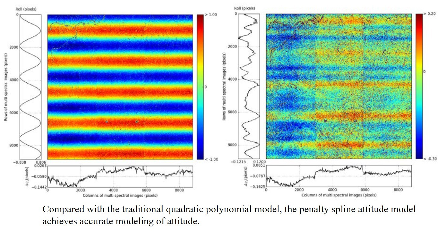
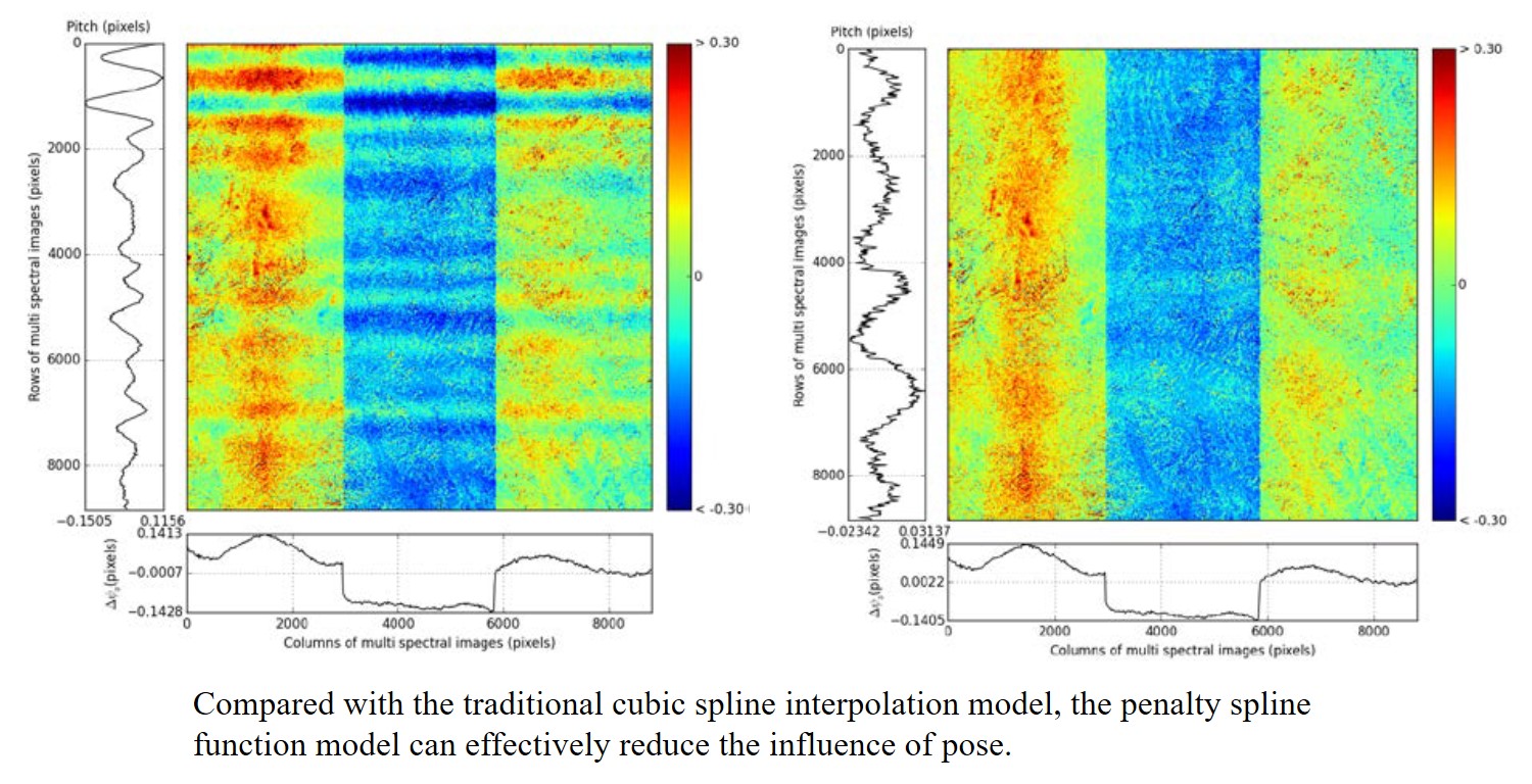
Latest research results1.A Penalized Spline-Based Attitude Model for High-Resolution Satellite ImageryAttitude models play a prominent role in the geometric processing of high-resolution satellite imagery (HRSI). Because of the high accuracy of the matching algorithm, attitude oscillations can occur in HRSI. Various methods for correcting this attitude oscillation with parallax observations have been proposed. However, few researchers have attempted to model the oscillation from the attitude records or have taken noise into consideration. In this paper, a penalized spline-based attitude model is proposed,which can model the oscillation with piecewise and continuously differentiable polynomials and smooth out the attitude noise with a penalty function. The balance between the fitting accuracy and noise smoothing is controlled by a penalty parameter, which is estimated by generalized cross-validation. Given that the attitude error introduces distortions into sensor-corrected images, the band-to-band registration of multispectral images is used to validate the attitude model. Five multispectral data sets captured by ZiYuan-3 are used to demonstrate the effectiveness of the proposed method. Compared with third-degree polynomials and cubic spline interpolation, the penalized spline model delivers the best performance by limiting the misregistration caused by the attitude model to within 0.1 pixels. PAN, H., ZOU, Z., ZHANG, G., ZHU, X., AND TANG, X. 2016. A penalized spline-based attitude model for high-resolution satellite imagery. IEEE Transactions on Geoscience and Remote Sensing, 54 (3):1849-1859.(IF 4.942) Pan H.,Zou Z. PENALIZED SPLINE: A GENERAL ROBUST TRAJECTORY MODEL FOR ZIYUAN-3 SATELLITE[J]. Int Arch Photogramm Remote Sens Spatial Inf Sci. 2016. XLI-B1365-372.
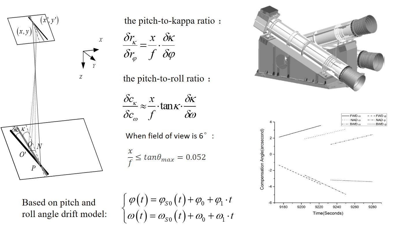
2.Attitude Compensation Model Based on Linear Drift Error
The rigorous sensor model (RSM) and the rational function model (RFM) are the most widely used geometric models for georeferencing. Even though geometric calibration and bundle adjustment with the RFM has been carried out for the ZiYuan-3 (ZY-3) earth observation satellite, few studies determined the major error sources affecting the three line cameras (TLCs). In this work, we propose a new set of compensation parameters, the shift and drift of both pitch and roll angle, for the RSM, since the yaw angle error is not as significant as the pitch angle for very narrow field of view images. Corresponding bias compensation methods are also validated for the RFM. Seven continuous strip scenes from the ZY-3 TLCs are used for the experiments, for which the root mean square error (RMSE) in the image space and object space are calculated. The experimental results demonstrate that the proposed method can model the major errors and achieve the same accuracy as the use of redundant parameters. With this model, the RMSEs of the checkpoints are 2.048 m in planimetry and 1.256 m in height. The RMSEs would increase to 2.522 m in planimetry and 2.635 m in height if the drift parameters were ignored. However, subpixel georeferencing accuracy is not as sensitive as the RMSE in the object space, since the RMSE of the height increases to 2.6 m compared to 1.3 m, while the change of the RMSE in the image space is within 0.1 pixels.In addition, the relationships among the TLCs are dynamic during imaging. Compensation for the TLCs as a unit introduces a height error of about 1 m, while maintaining subpixel georeferencing accuracy. Two ground control points (GCPs) placed at the beginning and the end of a strip are preferred to reduce oscillation and point picking errors. Compared with the RSM, the RFM can achieve similar accuracy when the drift compensation model and shift compensation model are applied. Pan, H., Tao, C. and Zou, Z., 2016. Precise georeferencing using the rigorous sensor model and rational function model for ZiYuan-3 strip scenes with minimum control, ISPRS Journal of Photogrammetry and Remote Sensing, 119:259-266.(IF 6.387)
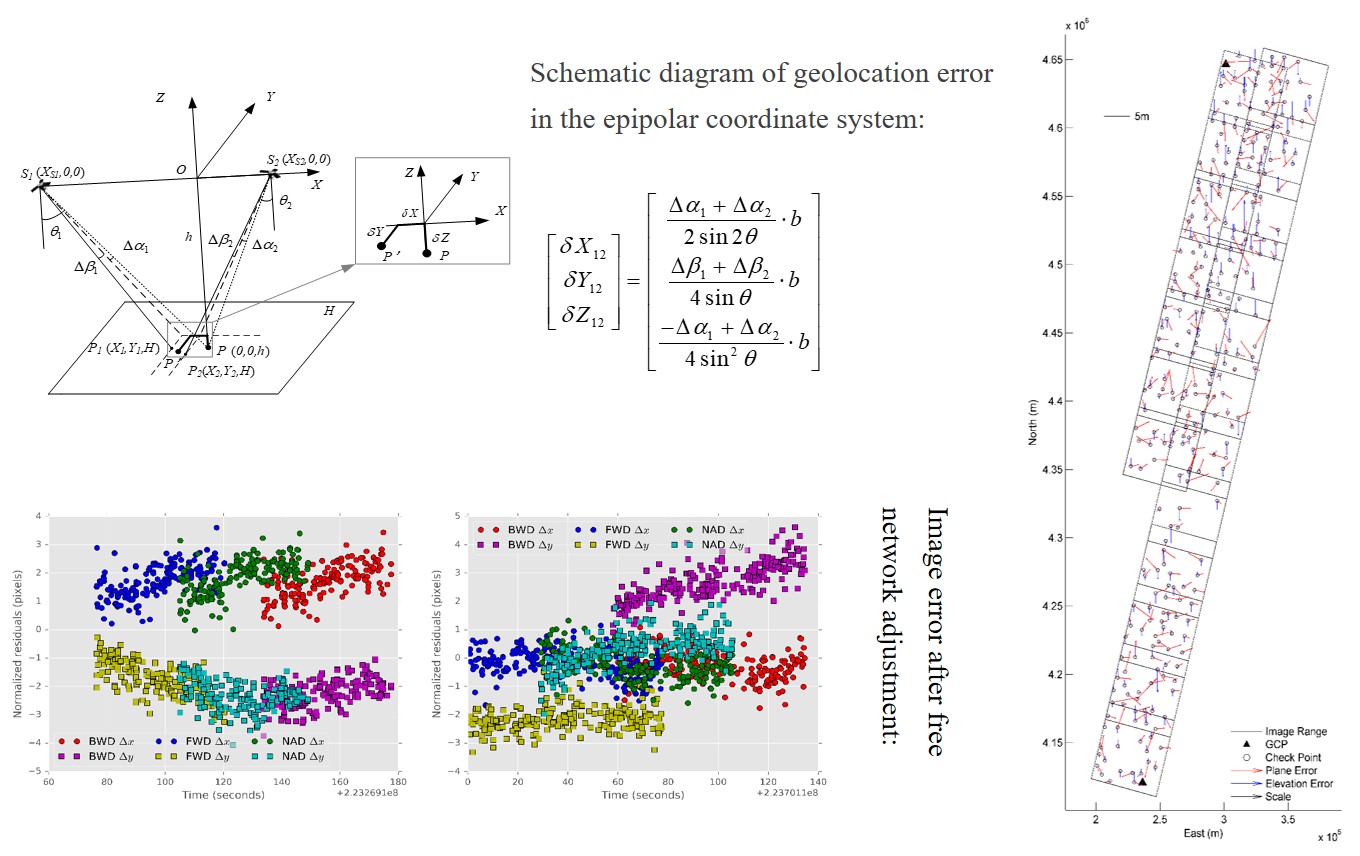
3.Research on Three-line Camera Error Compensation MechanismThe high-accuracy geolocation of high-resolution satellite images (HRSIs) is a key issue for mapping and integrating multi-temporal, multi-sensor images. In this manuscript, we propose a new geometric frame for analysing the geometric error of a stereo HRSI, in which the geolocation error can be divided into three parts: the epipolar direction, cross base direction, and height direction. With this frame, we proved that the height error of three line cameras (TLCs) is independent of nadir images, and that the terrain effect has a limited impact on the geolocation errors. For ZY-3 error sources, the drift error in both the pitch and roll angle and its influence on the geolocation accuracy are analysed. Epipolar and common tiepoint constraints are proposed to study the bundle adjustment of HRSIs. Epipolar constraints explain that the relative orientation can reduce the number of compensation parameters in the cross base direction and have a limited impact on the height accuracy. The common tie points adjust the pitch-angle errors to be consistent with each other for TLCs. Therefore, free-net bundle adjustment of a single strip cannot significantly improve the geolocation accuracy. Furthermore, the epipolar and common tie-point constraints cause the error to propagate into the adjacent strip when multiple strips are involved in the bundle adjustment, which results in the same attitude uncertainty throughout the whole block. Two adjacent strips—Orbit 305 and Orbit 381, covering 7 and 12 standard scenes separately—and 308 ground control points (GCPs) were used for the experiments. The experiments validate the aforementioned theory. The planimetric and height root mean square errors were 2.09 and 1.28 m, respectively, when two GCPs were settled at the beginning and end of the block. Pan, H., 2017. Geolocation error tracking of ZY-3 three line cameras, ISPRS Journal of Photogrammetry and Remote Sensing, 123:62-74.(IF 6.387)
|
|